


GPX Photo search
คำอธิบายของGPX Photo search
"GPX photo search" is Android app to search for photos taken in journey from the photo that is stored in the smart phone or Google photo.
Since the search in the shooting time even if you do not have organize your photos, have been recorded, is a Hassle
********************************************
I do not support writing geotag of external SD card on Android 4.4+.
I think that there is no choice but to copy the files to internal storage and process them.
********************************************
To use later, is required track log data (GPX file) were recorded leg of a journey.
This will make a move if you record GPS logger app.
(The GPS logger app, and you have Mountain trip logger)
In GPX photo search, use time of the track log and time the picture was taken (Exif) to find the photo data
※This free version shows ad at screen top. GOLD is ad-free version.
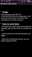
◆ How to use
Please send track log file (GPX) to GPX photo search.
[How to send]
・Place the SD card the GPX file, the file manager application (ES File Explorer, such as AndExplorer) to send
・In Mountain trip logger, press and hold the data you want to use the measurement results list screen, send in the form of share-GPX
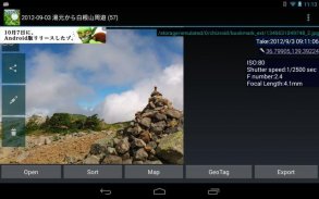
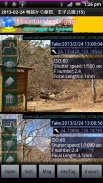
Then, the search will begin the photo. View photos from the SD card to find a smartphone, that are found.
Display mode is switched to tap the screen, you can turn off the button and find more information and get out.
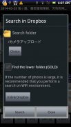
If a photo does not appear that there should be a photo but if, it may be funny to set the folder that you want to search for photos.
From Menu, setting, please try to change the settings of the folder you want to search.
Models also have built-in SD cards such as the Galaxy in particular areas, you may need to be changed.
▼ function (1) View photos every time
I think the camera is handy and they accumulated a lot of photos taken in various places.
And accumulate a lot, is very well to organize manually later.
However, it is all right if and when the track log data was taken, and GPX photo search.
Search even if they are not organized a photo, you can browse every time, you can output to a file.
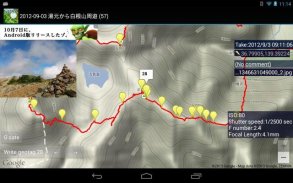
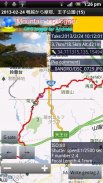
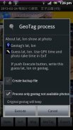
▼ function (2) Set the Geotagging Photos
As how to use slightly more advanced, the photo (geo) has not been set location information, you can also set a geotag.
(Measures of location information leakage) in the camera settings you think in many cases have taken off and then recording the geotag.
Even in such a case, fine, if the data and track logs when taken, the GPX photo search.
You can set the photo geotagging to estimate the latitude and longitude of the position taken by matching the track log time and the picture was taken, does not have a geotag.
The advantage of setting up as geotagging, apps and services that support geotagging: In (eg Picasa), you can put your photos on the map string.
Do not know when I look back later, be a more vivid memories.
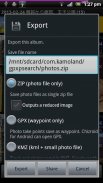
▼ function (3) Output file
It is for people who have a PC primarily, can be output to a file and search photos.
-Format ZIP (image)
Outputs a file all images taken in the journey. Can be used to take a backup on your computer, such as
-Format GPX (waypoints)
Gpx file that outputs the way point to point and shoot. You can import a point in compatible software.
-Format KMZ (track log + points + reduced image)
Outputs the data points with a track log and photos of stroke, are listed on the map. You can import in Google Earth
▼ function (4) Live wallpaper
Show photos as live wallpaper.
▼ function (5) Upload to Yamareco
http://www.yamareco.com/
"การค้นหาภาพถ่าย GPX" เป็นแอพ Android เพื่อค้นหารูปภาพที่ถ่ายในระหว่างการเดินทางจากภาพถ่ายที่เก็บไว้ในสมาร์ทโฟนหรือ Google Photo
ตั้งแต่การค้นหาในเวลาถ่ายภาพแม้ว่าคุณจะไม่ได้จัดระเบียบรูปภาพของคุณได้รับการบันทึกเป็นความยุ่งยาก
********************************************
ฉันไม่สนับสนุนการเขียนระบุตำแหน่งของการ์ด SD ภายนอกบน Android 4.4 ขึ้นไป
ฉันคิดว่าไม่มีทางเลือกนอกจากคัดลอกไฟล์ไปยังที่จัดเก็บข้อมูลภายในและประมวลผลไฟล์เหล่านั้น
********************************************
หากต้องการใช้ในภายหลังจำเป็นต้องมีข้อมูลบันทึกการติดตาม (ไฟล์ GPX) ที่บันทึกการเดินทาง
นี่จะเป็นการย้ายถ้าคุณบันทึกแอป GPS logger
(แอพ GPS logger และคุณมี Mountain trip logger)
ในการค้นหาภาพถ่าย GPX ให้ใช้เวลาของบันทึกการติดตามและเวลาที่ถ่ายภาพ (Exif) เพื่อค้นหาข้อมูลภาพถ่าย
※เวอร์ชั่นฟรีนี้แสดงโฆษณาที่ด้านบนของหน้าจอ GOLD เป็นรุ่นที่ไม่มีโฆษณา
◆วิธีใช้
โปรดส่งไฟล์บันทึกการติดตาม (GPX) ไปที่การค้นหาภาพถ่าย GPX
[วิธีการส่ง]
・ วางไฟล์ GPX ใน SD card ซึ่งเป็นแอปพลิเคชั่นตัวจัดการไฟล์ (ES File Explorer เช่น AndExplorer) เพื่อส่ง
・ ในตัวบันทึกการเดินทางบนภูเขาให้กดข้อมูลที่คุณต้องการใช้หน้าจอรายการผลการวัดค้างไว้ส่งในรูปแบบของ share-GPX
จากนั้นการค้นหาจะเริ่มต้นรูปภาพ ดูรูปถ่ายจากการ์ด SD เพื่อค้นหาสมาร์ทโฟนที่พบ
โหมดการแสดงผลถูกสลับเพื่อแตะหน้าจอคุณสามารถปิดปุ่มและค้นหาข้อมูลเพิ่มเติมและออกไป
หากรูปถ่ายไม่ปรากฏว่าควรมีรูปถ่าย แต่ถ้าเป็นเช่นนั้นอาจเป็นเรื่องตลกที่จะตั้งค่าโฟลเดอร์ที่คุณต้องการค้นหารูปถ่าย
จากเมนูการตั้งค่าโปรดลองเปลี่ยนการตั้งค่าของโฟลเดอร์ที่คุณต้องการค้นหา
รุ่นนี้ยังมีการ์ด SD ในตัวเช่น Galaxy ในบางพื้นที่คุณอาจต้องเปลี่ยน
ฟังก์ชั่น▼ (1) ดูรูปภาพทุกครั้ง
ฉันคิดว่ากล้องมีประโยชน์และพวกเขาสะสมภาพถ่ายจำนวนมากในที่ต่างๆ
และสะสมเป็นจำนวนมากเป็นอย่างดีในการจัดระเบียบด้วยตนเองในภายหลัง
อย่างไรก็ตามมันเป็นสิ่งที่ถูกต้องถ้าและเมื่อข้อมูลบันทึกการติดตามถูกถ่ายและการค้นหาภาพถ่าย GPX
ค้นหาแม้ว่าพวกเขาจะไม่จัดระเบียบภาพถ่ายคุณสามารถเรียกดูทุกครั้งที่คุณสามารถส่งออกไปยังไฟล์
ฟังก์ชั่น▼ (2) ตั้งค่าตำแหน่งแท็กตำแหน่ง
วิธีการใช้ขั้นสูงกว่าเล็กน้อยภาพถ่าย (ภูมิศาสตร์) ยังไม่ได้รับการตั้งค่าข้อมูลตำแหน่งคุณยังสามารถตั้งค่าตำแหน่งแท็กได้
(มาตรการการรั่วไหลของข้อมูลตำแหน่ง) ในการตั้งค่ากล้องที่คุณคิดว่าในหลาย ๆ กรณีได้ถูกนำออกไปแล้วบันทึกตำแหน่งทางภูมิศาสตร์
แม้ในกรณีเช่นนี้ก็ดีถ้าข้อมูลและติดตามบันทึกเมื่อถ่ายแล้วการค้นหาภาพถ่าย GPX
คุณสามารถตั้งค่าการใส่แท็กตำแหน่งของภาพถ่ายเพื่อประมาณค่าละติจูดและลองจิจูดของตำแหน่งที่ถ่ายโดยการจับคู่เวลาของแทร็กแทร็กและภาพที่ถ่ายนั้นไม่มีแท็กระบุตำแหน่ง
ข้อดีของการตั้งค่าเป็นแท็กตำแหน่งแอปและบริการที่สนับสนุนการติดแท็กตำแหน่ง: ใน (เช่น Picasa) คุณสามารถใส่รูปภาพของคุณลงในสตริงแผนที่
ไม่ทราบว่าเมื่อฉันมองย้อนกลับไปในภายหลังเป็นความทรงจำที่สดใสมากขึ้น
ฟังก์ชั่น▼ (3) ไฟล์เอาต์พุต
สำหรับผู้ที่มีพีซีเป็นหลักสามารถส่งออกไปยังไฟล์และค้นหาภาพถ่าย
จัดรูปแบบ ZIP (ภาพ)
ส่งไฟล์ภาพทั้งหมดที่ถ่ายในการเดินทาง สามารถใช้เพื่อสำรองข้อมูลในคอมพิวเตอร์ของคุณเช่น
จัดรูปแบบ GPX (จุด)
ไฟล์ Gpx ที่ส่งออกทางชี้ไปที่จุดและยิง คุณสามารถนำเข้าจุดในซอฟต์แวร์ที่เข้ากันได้
จัดรูปแบบ KMZ (บันทึกการติดตาม + คะแนน + ภาพลดลง)
ส่งออกจุดข้อมูลที่มีบันทึกการติดตามและภาพถ่ายของโรคหลอดเลือดสมองมีการระบุไว้ในแผนที่ คุณสามารถนำเข้าใน Google Earth
ฟังก์ชั่น▼ (4) วอลล์เปเปอร์สด
แสดงรูปภาพเป็นวอลล์เปเปอร์สด
ฟังก์ชั่น▼ (5) อัปโหลดไปยัง Yamareco
http://www.yamareco.com/
GPX Photo search--เวอร์ชั่น7.9
(08-07-2021)GPX Photo search - ข้อมูล APK
เวอร์ชั่น APK: 7.9แพ็คเกจ: com.kamoland.gpxpsearchเวอร์ชั่นล่าสุดของGPX Photo search


แอปในประเภทเดียวกัน


